(
click on photo to enlarge)
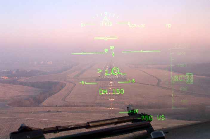
This photo was taken from the cockpit jump seat and it shows the view through the Heads Up Display (HUD) that Southwest Pilots use to find the airport in weather. It repeats all the necessary flight instrument data that the main instruments on the dash depict, all in one easy to find location. The nifty thing about the HUD is it allows SWA Captains to remain focused out in the distance looking for the runway at Minimum Descent Altitude (MDA) on the approach. That is the final time the Pilot can continue the approach. If the runway is not in sight by then, the pilot must execute the "go around" procedure.
The airspeed information is to the left (not in view in this photo), altitude to the right, radar altitude below and to the right of the "DH 150" notation (this denotes that the "decision height" is 150 feet--the point at which the decision to land or go around must be made) and most importantly, the Flight Path Vector symbol on or near the runway. That is a pretty accurate instantaneous estimate by the HUD computer where the aircraft is flying to, in this case, just to the right of the runway aside the touchdown point. The Flight Path Vector Symbol also shows the airspeed relative to the speed selected by the Pilots for the approach, as well as whether the aircraft is accelerating (gaining energy) or slowing down (losing energy) relative to that selected speed. This is great information to have because it is often your first indication of an upcoming loss of airspeed, as in a windshear event.
The HUD. Another great tool we use to get our passengers where they need to be, safely and securely. (My partner was flying this approach and I was monitoring through the HUD for this picture.) Note the nifty runway identification lights illuminating where the runway starts.
Captain Ray Stark